
Play
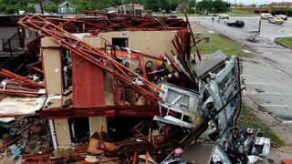
- Homes were damaged in Oklahoma.
- Wind gusts up to 70 mph were reported in Texas.
- Golf-ball sized hail fell in Missouri.
Severe weather carved a path across parts of the Central and Southern Plains for a second day in a row Saturday, bringing flash flooding to parts of Texas and Kansas and damaging homes in Oklahoma.
By Saturday night, there were dozens of reports of tornadoes, flash flooding and high winds from North Texas to southern Wisconsin.
That included golf-ball sized hail in Holt County, Missouri, and a 78 mph wind gust in Fisher County, Texas
Here are our updates as the storms moved through Saturday.
(11:30 p.m. ET) Tornadoes Touch Down In Oklahoma
Following what was a relatively calm day across central Oklahoma, several tornadoes have touched down along and just east of Interstate 35. Radars have confirmed tornadoes near Ardmore, Norman, Sulfur, and Spaulding, Oklahoma.
(9:04 p.m. ET) Storms, Flooding Continue Overnight
From weather.com digital meteorologist Jonathan Belles:
Storms this evening will slowly coalesce into a robust, but slow-moving line of thunderstorms across the Plains and Midwest overnight. These storms will bring a high likelihood for nocturnal flash flooding, damaging winds and a few tornadoes. Storms will continue to gradually shift eastward on Sunday in parts of the Missouri Valley and Arklatex.
(8:43 p.m. ET) Heavy Rain, Flooding In Kansas
Some areas of southeast Kansas have received between 4 and 8 inches of rain over the past 24 hours.
The National Weather Service in Wichita shared a photo of a highway covered in water with the important reminder: “Turn Around, Don’t Drown.”
(7:59 p.m. ET) Should You Open Your Windows?
Opening your windows when a tornado is closing in is a myth that originated with the idea that equalizing pressure in a house would keep it from exploding.
“It’s useless and you’d be wasting precious time to get to real safety before a tornado strikes,” weather.com senior meteorologist Chris Dolce wrote in a recent article. “It’s the high winds and flying debris that cause damage to structures, not a pressure difference.”
Read more: 10 Tornado Myths Busted
(7:31 p.m. ET) Surveys, Cleanup Ongoing in Areas Hit Yesterday
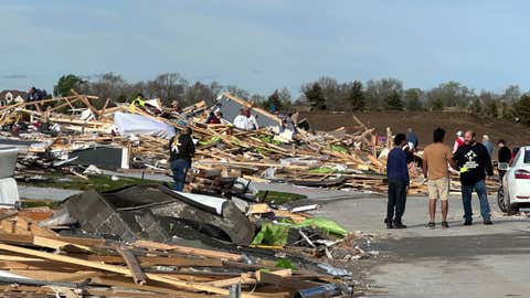
The National Weather Service in Des Moines, Iowa, has confirmed nine tornadoes touched down in the state Friday. Surveys are ongoing. Six were rated EF2, with winds ranging from 125 mph to 135 mph.
The tornado with the longest track was on the ground more than 26 miles in Ringgold County, Iowa, near the state line with Missouri.
In Nebraska, police said today that 150 homes were damaged or destroyed in Omaha Friday.
“We barely made it to the basement and then we heard the destruction going on upstairs,” James Stennis, who lives in the Omaha suburb of Elkhorn, told The Associated Press. “Wow!”
(7:03 p.m. ET) After Devastating Friday, Nebraska Is Again In The Path Of Storms
Parts of Nebraska including Lincoln and Omaha are under threat again after tornadoes devastated some areas around those two cities yesterday. The good news is that tornadoes aren’t likely, but people there should expect some potentially strong thunderstorms packing hail and rain.
(6:22 p.m. ET) Flash Flooding Ongoing In Western North Texas
As mentioned earlier, tornadoes, hail and wind aren’t all we’re worried about tonight. Flash flooding is ongoing in parts of western North Texas and is likely to get worse as the evening goes on.
(5:58 p.m. ET) Here’s Why Supercells Are So Dangerous
During a tornado outbreak like this one, you’ll often hear us mention supercell thunderstorms. Supercells are powerful, rotating storms that can produce large hail, high winds and tornadoes.
Most commonly found in the Plains, supercell thunderstorms are packed with energy and can track for hours over hundreds of miles.
If winds above the ground are much faster and from a different direction than near the ground, that causes the air between to spin slowly around a horizontal axis.
They form when those columns of air interact with heat and humidity, tilt vertically and grow tall. That causes circulation around a vertical axis, and creates that ominous-looking “mother ship” appearance.
As few as 20% of supercell thunderstorms produce tornadoes, but they are among the most violent we see.
(5:36 p.m. ET) NWS Norman: Heads Up, Warnings Could Be Delayed
The National Weather Service in Norman, Oklahoma, is receiving reports of delays in warnings going to NOAA Weather Radio.
“Given the serious situation ongoing, please consider other methods of receiving warnings such as TV coverage, WEAs on your phone, or our social media accounts,” the NWS said in an update on X.
The issue is an important reminder of why it’s so important to have multiple ways of receiving weather alerts.
(5:27 p.m. ET) Top Winds So Far Today
A wind gust of 60 mph was reported in Douglass, Kansas, about 20 miles southeast of Wichita.
A gust of 59 mph was reported in rural Knox City, Texas. A tornado was also confirmed in that area.
(5:15 p.m. ET) Warmer Layer Might Be Keeping A Lid On Storms, For Now
From weather.com digital meteorologist Jonathan Belles:
Measurements between 1-2 miles above the ground indicate that there is a small warmer layer aloft that might be keeping a little bit of a lid on thunderstorms this afternoon. Thunderstorms with strong rotation or a little help from boundaries like a cold front or dryline are having no problem breaking through to tornadogenesis.
Storms deep in the warm sector are having a small bit of trouble getting their spins going. This may change this evening as winds aloft typically accelerate and humidity rises during the evening hours. In Oklahoma and northern Texas, the dryline will also mix eastward through the evening, adding additional lift.
Read more: Classic Ingredients Needed For A Severe Weather Outbreak
(4:57 p.m. ET) Omaha Police: Lucky There Weren’t More Injuries
As cleanup began today in areas hard hit by last night’s round of severe weather, many communities felt relief.
There are so far no reports of deaths or major injuries.
In hard-hit areas of Omaha, for example, only two people were transported to hospitals.
Omaha Police Chief Todd Schmaderer credited that to early warning systems in the city and Douglas County, according to the Omaha World-Herald.
“We were not hit upon by a sudden storm,” Schmaderer said. “People had warning of this.”
Read how Friday’s outbreak unfolded here.


(4:38 p.m. ET) Homes Damaged In Oklahoma
There are reports of substantial damage to a couple of homes near Enid, Oklahoma, this afternoon. The town is in Garfield County about 70 miles north of Oklahoma City. The Garfield County Sheriff’s Office said in a social media post that deputies and first responders were on the scene.
(3:29 p.m. ET) No Rest For The Weary
These storms are expected in an area that’s already seen its fair share of severe weather this weekend.
The National Weather Service just finished preliminary damage assessments in Texas following heavy storms there on Friday. They found three separate tornadoes in Navarro County – two that were pretty strong, reaching EF1 status – and one smaller one near Frost, Texas.
There were at least three more tornadoes in Mclennan and Hill Counties, including a stronger EF2 near the town of West. Officials are still working through the damage in Hill County. We’ll likely get more details later tonight, but it could take a few days for the full report.
Tornado surveys across the rest of the Plains, including hard-hit Nebraska and Iowa, could take days to weeks to complete.
(2:55 p.m. ET) Particularly Dangerous Situation Ongoing
From weather.com digital meteorologist Jonathan Belles:
NOAA’s Storm Prediction Center has issued a “Particularly Dangerous Situation” tornado watch for parts of the Plains. This designation signifies the high likelihood of large hail and strong tornadoes that pose a significant threat to life and property, particularly in swaths of Oklahoma and Texas. There is also a likely threat of some higher-end, longer-lasting tornadoes continuing in the area later this evening.


(2:26 p.m. ET) High-End Flood Threat Not To Be Forgotten
The highest possible threat for flash flooding has been issued across parts of central Oklahoma. This level of flooding often brings rainfall-related fatalities and a sizeable amount of flood-related damage. Experts don’t issue this alert lightly.
(MORE: Why You Should Pay Attention to ‘High Risk’ Flood Forecasts)


This rain is expected in areas that have already seen wet weather (and even severe weather) in recent days, making for waterlogged ground that’s likely already sustained a bit of damage. The repeated threat of severe weather means even training rainfall could prove to be life-threatening.
Here’s what to do when tornado and flash flood warnings are issued simultaneously.
The Weather Company’s primary journalistic mission is to report on breaking weather news, the environment and the importance of science to our lives.