LUBBOCK, Texas (KCBD) – Scurry County Judge Dan Hicks has declared a disaster and is requesting assistance from the state after one of the strongest earthquakes in Texas history caused damage across the area Friday morning.
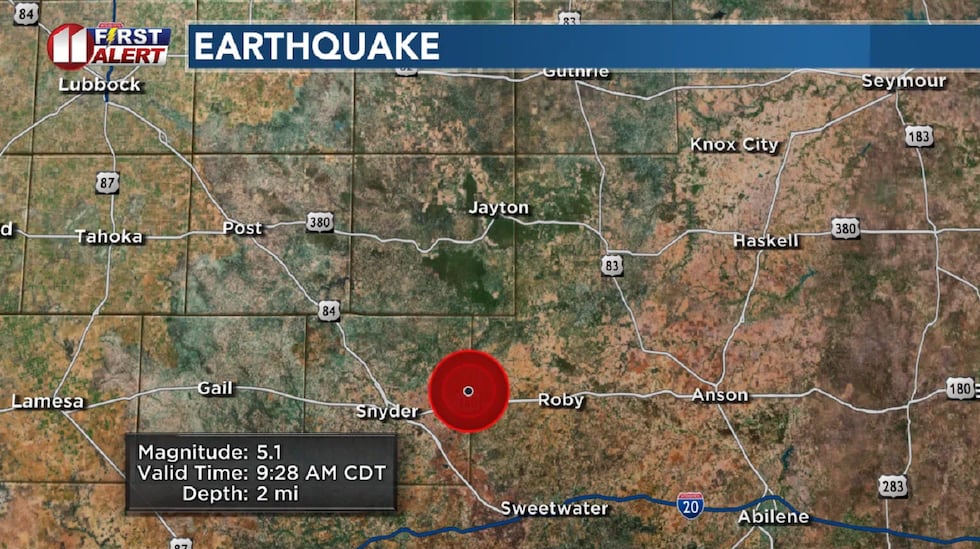
According to the USGS, a 5.1-magnitude quake occurred east of Snyder, northeast of Hermleigh. It was felt about 80 miles to the northwest in Lubbock, and across parts of the South Plains and West Texas. On the Modified Mercalli Intensity (MMI) scale, the USGS shows a VI-Strong rating. The USGS again updated the magnitude, now to 5.1 as of 11 a.m. There were also aftershocks of 3.2 at 9:40 and 2.7 at 10:44.
Over the past week there have now been dozens of earthquakes across Scurry and Fisher counties, with several this afternoon. Watch the count here.
Judge Hicks said Scurry County has experienced 61 earthquakes in the last seven days.
“Since the first earthquake that was felt on July 22, 2024 at about 9:38 PM, a 4.9, and a 4.4 at about 9:46 PM to today’s 5.0 at about 9:28 AM July 26, 2024, damage has been found throughout Scurry County in businesses and residences,” Hicks wrote on Facebook. He said emergency management coordinator Jay Callaway is working closely with the Texas Department of Emergency Management to monitor the damage throughout Scurry County and the surrounding area.
If you have any damage please go to the below website and complete the iSTAT form. English and Spanish versions are available.
Texas earthquake history
The USGS has updated the strength of Friday morning’s earthquake to 5.1-magnitude, which now places it at fifth-strongest earthquake recorded in Texas history.
| When? | Where? | Magnitude | MMI Scale |
|---|---|---|---|
| Aug. 16, 1931 | Presidio County, near Valentine | 5.8 | VIII Severe |
| April 14, 1995 | Brewster County | 5.7 | VII Very Strong |
| Nov. 16, 2022 | Reeves County | 5.4 | VII Very Strong |
| Nov. 8, 2023 | Reeves County | 5.2 | VII Very Strong |
| Dec. 16, 2022 | Martin County | 5.2 | VI Strong |
| Today | Scurry County, east of Snyder | 5.1 | VI Strong |
| March 26, 2020 | Reeves County | 5.0 | V Moderate |
| July 30, 1925 | Carson County | 4.9 | VI Strong |
| July 21, 2022 | Culberson County | 4.9 | V Moderate |
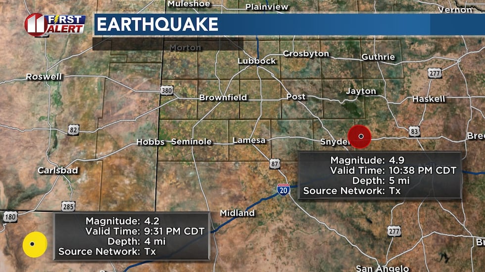
| Monday night | Fisher County, east of Snyder | 4.9 | V Moderate |
What’s the difference between earthquake magnitude and intensity? USGS answers this question.
According to the USGS, it occurred at 9:28 a.m. Friday at a depth of about two miles, about eight miles northeast of Hermleigh. This is near U.S. 180 on the Scurry-Fisher county line. A 3.2-magnitude quake followed at 9:40 a.m. at nearly the same location. There was also a 2.6-magnitude quake Thursday morning in this area.
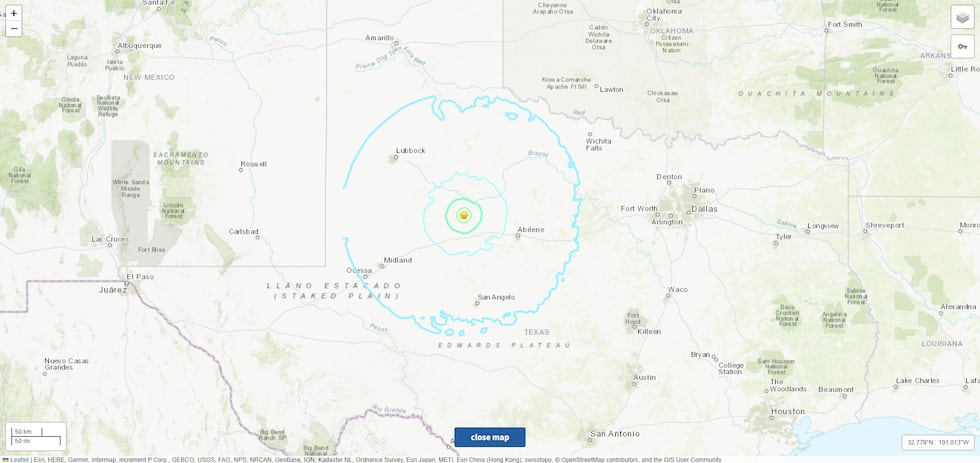
The map below shows roughly where the 5.1-magnitude earthquake could have been felt, with minor shaking noted to Lubbock, Odessa, Midland, Abilene and San Angelo. You can report to the USGS if you felt the tremor Friday morning.
This comes just days after a 4.9-magnitude quake occurred close to this same area Monday night, on the east side of the county line, followed by aftershocks that night including a 4.4-magnitude quake. The strongest Monday night earthquake had a depth of 4.8 miles. The image below shows the strongest Monday night quake as well as another one that occurred an hour earlier west of Pecos.
Regulatory Investigation
The Texas Railroad Commission, which regulates oil and gas operations in the state, is investigating this week’s quakes in the Camp Springs area and along the Fisher-Scurry County line.
Here is a statement from the RRC:
“In efforts to reduce seismicity possibly caused by underground injection of produced water, several operators in the area have converted deep saltwater disposal wells to shallow saltwater disposal wells within the last year. (Disposal wells are used to dispose produced water, which is water that comes out from wells during oil and gas production.) RRC inspectors are out inspecting saltwater disposal wells within two and a half miles of the cluster of earthquakes this week and the RRC will evaluate next steps that can be taken to mitigate earthquakes. We’ll continue to take measures necessary to protect the environment and residents in the area.”
Not specific to this week, on a broad scale according to the USGS website, fracking is not directly causing most induced earthquakes. “It’s the disposal of waste fluids that are a byproduct of oil producing that is the primary cause of the the recent increase in earthquakes in the central United States,” the USGS states on this page: Myths and Misconceptions About Induced Earthquakes. Additionally, it states not all wastewater injection wells induce earthquakes.
Expert Insight
On Friday, KCBD spoke with Harold Gurrola, an associate professor at Texas Tech University who studies geophysics.
He tells KCBD that West Texas is no stranger to earthquakes. In fact, they’ve occurred long before oil production came to the area.
“They were less frequent but there were earthquakes. Those really old faults have pressure built up that can get triggered later,” said Gurrola.
While the USGS says that wastewater disposal wells are the primary cause of the recent increase in earthquakes, Gurrola says it’s way too early to point fingers.
“Tectonic forces load up the fault, but then it comes down to ‘What’s the straw that broke the camel’s back?’ because if that fault is on the verge of breaking, then something can break it. It’s one of these things where you can say overall, over a period of years, yes there are more earthquakes because of oil activity, but you can’t say that this one was caused by oil activity,” said Gurrola.
Copyright 2024 KCBD. All rights reserved.