From droughts and floods to big hail and tornadoes. Here’s what we’ll remember from 2024.
DALLAS — As we say goodbye to 2024, let’s take a look back at the weather we saw during the year. Here’s a rundown of some records, stats and a recap of the most memorable weather events of 2024.
Quick Facts
- Our average temperature for the year as of now is 69.7 F, which is tied with LAST YEAR as the 2nd warmest year on record. We will see where this lands, but with warmer than normal temps expected to end the year, it likely remains a top five warmest year on record for DFW.
- We had the deadliest tornado in Texas since 2015.
- Rainfall this year totaled 38.36 inches, which is above the normal yearly rainfall of 37.01 inches. Most of this came in spring before a dry summer and fall. This is the first year since 2020 we’ll end with an annual surplus.
- The coldest temp of the year was 11° F back on Jan. 15.
- The hottest temp of the year was 107° F. This happened on Aug. 19.
- It was the 14th warmest summer on record.
- October was the warmest on record. The average temp was 75.7° which is 1.6° warmer than second place (2016).
- Officially, the year ended up with 1.5 inches of snowfall. This is very close to the normal of 1.6″. All of which occurred during an event that passed through Jan. 14 and 15 along with the most significant cold of the year.
General pattern
After three years in a row of La Niña conditions from 2020-2023, El Niño developed around the beginning of summer of 2023. El Niño continued to hold through the beginning of 2024, but by the time we hit summer, we fell into ENSO-neutral conditions.
We don’t see much benefit from ENSO neutral during the summer months, so it was indeed a hot one. It also contributed to the warm and dry end to Fall we had as we began our drop into La Niña conditions for the winter. More on what that means for this winter down below.
Winter 2024: Arctic Blast and Snowfall
The year began with an arctic blast that brought frigid temperatures and snowfall to the Dallas-Fort Worth area. Temperatures remained below freezing for approximately 89 consecutive hours, with lows plunging into the teens and wind chills in the single digits mid-January. The snowfall, though generally light and fluffy, resulted in accumulations of less than an inch in most areas, with some locations experiencing slightly higher totals due to lake-effect snow. That’s right — lake effect in North Texas. Do you remember it?
Spring 2024: Deadly tornadoes
May was marked by severe weather, including powerful storms and tornadoes. Over Memorial Day weekend, a devastating tornado struck Valley View, about 60 miles north of Dallas, resulting in seven fatalities, including two children, and injuring nearly 100 people. This was the deadliest tornado in Texas since 2015. The tornado caused extensive damage to homes and businesses, particularly affecting a mobile home park and a gas station where many sought shelter.
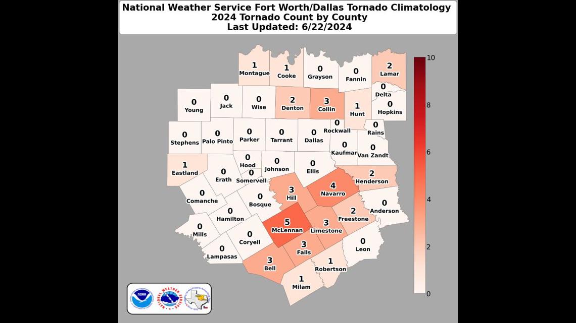
We saw a total of 20 tornadoes in our viewing area this season. Here’s the county breakdown.


Later in May, another round of severe storms swept through the Dallas-Fort Worth area, bringing wind gusts exceeding 70 mph. The Colony recorded a peak wind gust of 95 mph. These intense winds led to widespread power outages, downed trees, and significant property damage.
Also of note, 2024’s spring ended up being the 8th wettest on record with just under 20″ of rain.
Summer: Above-Normal Heat
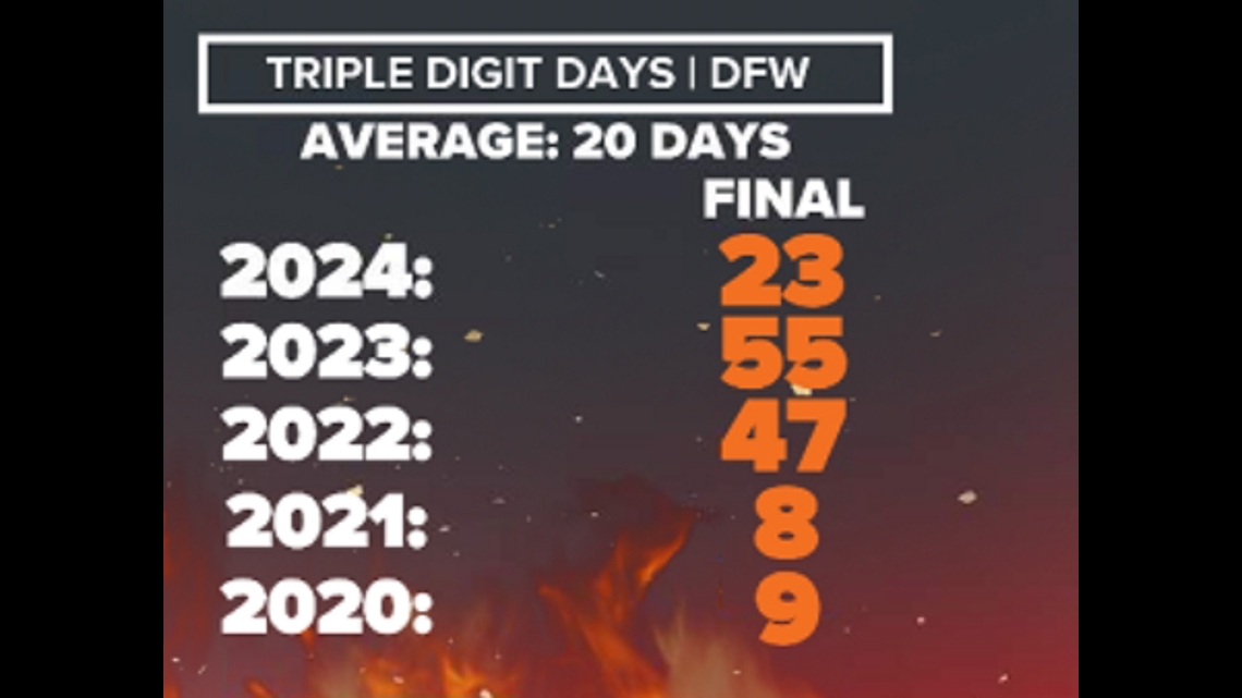
The summer of 2024 was notably hot, ranking as the 14th hottest on record for North Texas. We peaked at 107°. We experienced 23 days with temperatures reaching or exceeding 100°F, slightly above the average of 20 such days per year. The wet spring leading into summer helped keep the triple-digit number down quite a bit. While this was fewer than the 55 triple-digit days recorded in 2023, it was the third summer in a row of above-normal 100° days. We’re overdue for a less hot summer!


Fall: Warm and dry
The fall was rather dry and warm. In fact, the end of summer and fall really affected the rainfall surplus we gained from the spring. We ended up slipping most of the region into moderate to even extreme drought conditions after a nearly rainless October. It was dry all of October minus the very last day (Halloween). It rained that morning which saved it from being the driest October on record. We only picked up 0.21″ of rain. October was the warmest on record: the average temp was 75.7° which is 1.6° warmer than second place (2016).
On the positive side: it was relatively quiet. Fall is typically our secondary severe weather season, but we really avoided seeing much significant severe weather.
Looking ahead to the winter:
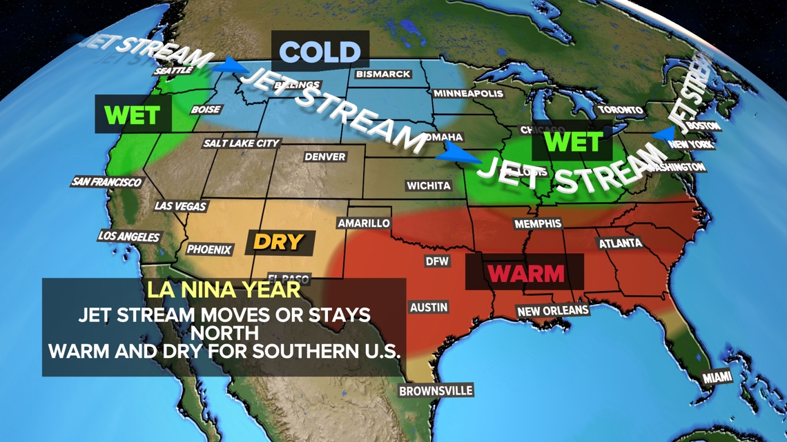
La Niña conditions are expected to settle in for the upcoming winter and that has an impact on what we expect.


These shifts usually bring an overall drier and warmer-than-normal winter for North Texas. And that’s exactly what we expect this year. Does this mean it will never snow, ice or be brutally cold at times? No. It just means when we look back at the winter months and average all the precipitation and temperature numbers we expect a rainfall deficit and warmer than normal averages.