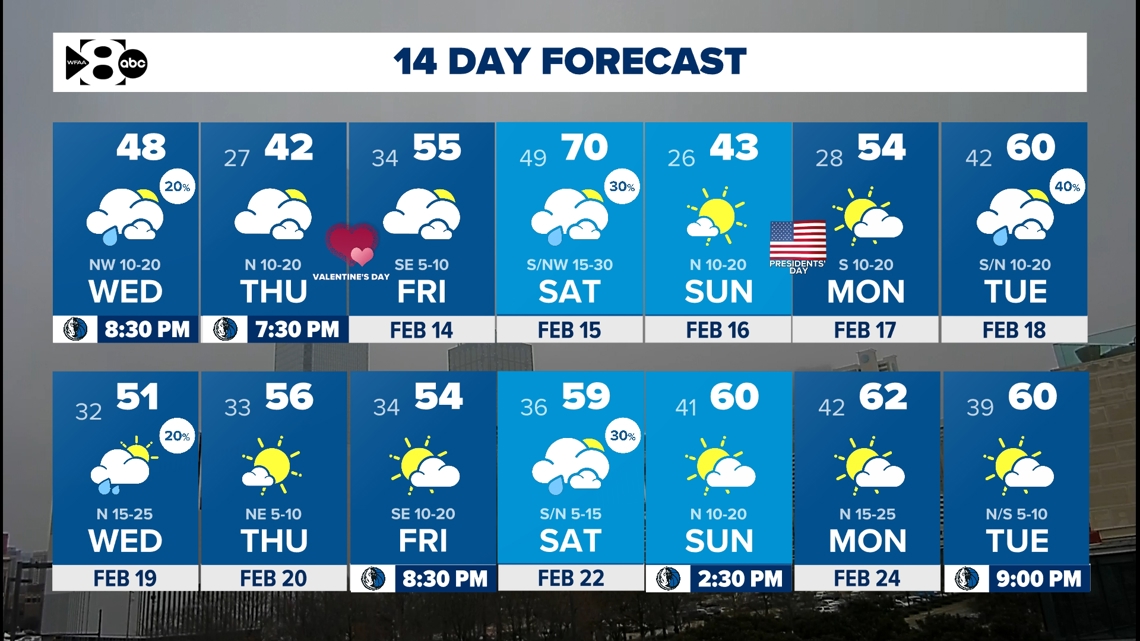
A series of cold fronts keep North Texas on a temperature roller coaster ranging from freezing temps to near 70°.
DALLAS — Watch live radar and forecast updates on the WFAA+ streaming app and download the WFAA app for alerts from our team.
North Texans should brace for a series of temperature swings as three cold fronts move through the region over the next week. The first strong front arrives today, bringing a sharp drop in temperatures overnight and setting the stage for a frigid Thursday.
Key Takeaways
- Freezing temps and wind chills in the teens Thursday morning
- A warm-up into the weekend is expected
- Brief rain Friday night – Saturday morning
- Strong cold fronts Saturday and next Tuesday
Storms move out, cold blast settles in
Wednesday morning started with loud thunderstorms bringing heavy rain, 40 mph wind gusts,s and pea size hail in some areas. While severe weather was not a major concern, a localized flood threat caused problems on the roads. Now that the rain is out, low clouds will linger as drier air surges in.
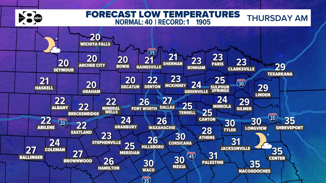
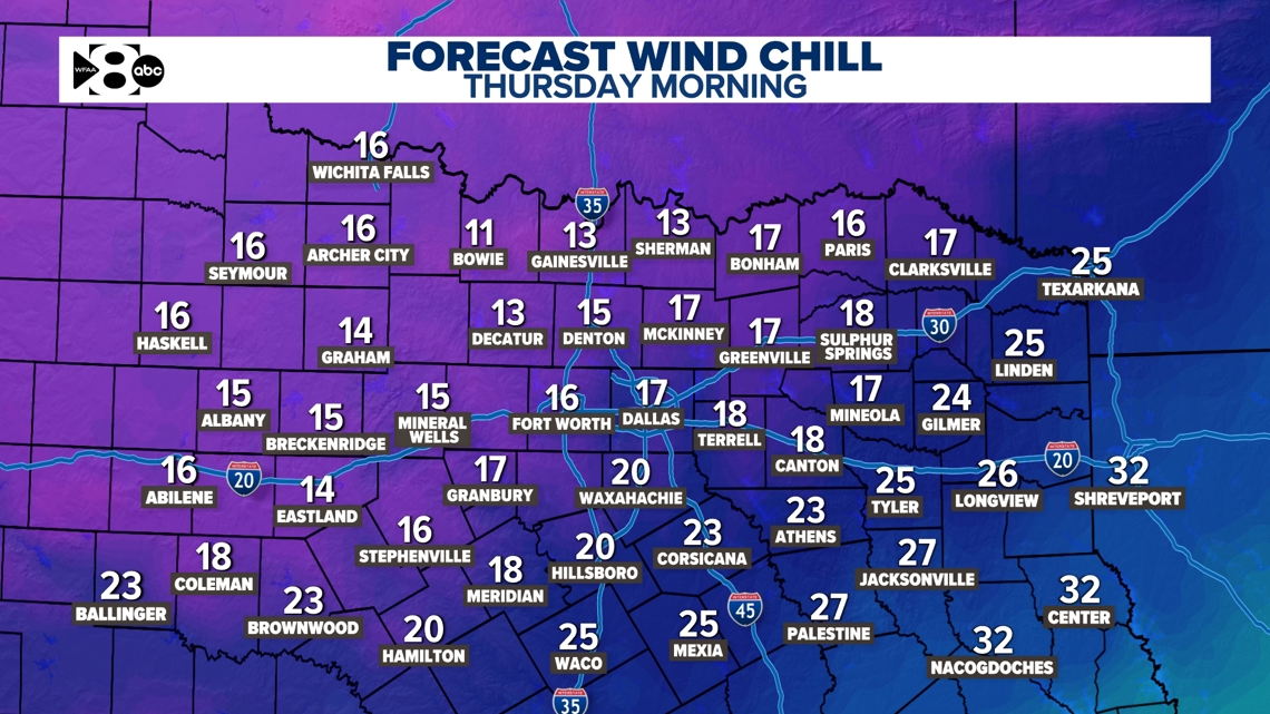
A powerful cold front will push through the region Wednesday afternoon and evening. Temperatures will take a large dip overnight. DFW’s temp will be at or near freezing by midnight. It’ll continue to drop plunging into the 20s by Thursday morning. A frigid north wind will make it feel even colder with wind chills in the teens.
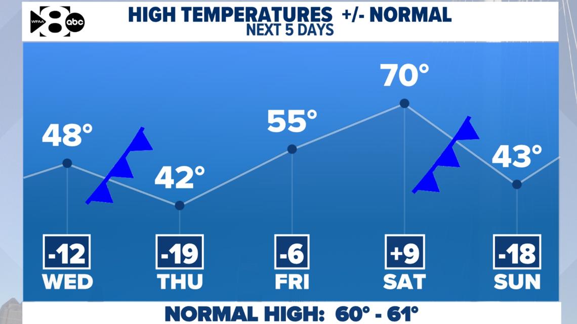
Thursday morning will be the coldest period of the week. With freezing temperatures, it is important to note that any rain not dried up from the early week’s rain could freeze. Unfortunately, this could cause slick spots. Despite sunshine, highs will struggle to warm on Thursday, remaining 15 to 20 degrees below normal for mid-February.


Rain & a weekend warm-up followed by another arctic front
Friday marks the start of a brief warming trend as sunshine and southerly winds return. This will push temperatures to the 50s on Friday and near 70 by Saturday. The warmer weather comes to a stark halt as another strong cold front arrives in North Texas. Some showers and storms are expected ahead of the front as early as Friday evening and lasting through Saturday morning. Severe weather is not expected with this next round of rain and coverage will be lower than Wednesday morning’s storms. Sunday morning will be freezing with lows in the 20s and wind chills in the teens. Highs on Sunday will be near twenty degrees cooler than normal for mid-February.

14-day
Near normal temperatures finally return next Tuesday. Again, another arctic front brings temperatures tumbling down for the middle parts of the week. It does look like that front could produce some precipitation. However, it is a bit too soon to detect if that will be in the form of wintry precipitation. Be sure to keep checking back in!