CORPUS CHRISTI, Texas — Texas is now bracing for the threat of Beryl, which is expected to produce heavy rainfall and hurricane-force wind gusts for a large chunk of the state and northeastern Mexico.
Beryl weakened into a tropical storm Friday afternoon after pummeling Mexico’s Yucatán Peninsula but is forecast to regain hurricane strength over the warm waters of the Gulf of Mexico.
A Hurric ane Watch has been issued for much of Texas’ coastline, south of the Houston/Galveston metro.
A Storm Surge Watch is also now in effect from the Rio Grande northward to High Island, Texas. A Storm Surge Watch means there is a potential for life-threatening water rises within the next 48 hours.
KNOW YOUR ZONE: TEXAS HURRICANE EVACUATION ZONES

Storm Surge models indicate a water rise of 5 feet is possible as Beryl approaches late in the weekend and early in the week.
Mexico‘s government has also issued a Hurricane Watch from Barra el Mezquital to the mouth of the Rio Grande.
Forecasts indeed show Beryl’s weakening trend over land Friday morning will reverse once Beryl gets back over the warm, open waters of the Gulf of Mexico on Friday, slowly regaining strength.
Computer models show the atmosphere in the western Gulf of Mexico will become less hostile to tropical development over the weekend while the storm begins to feed off water temperatures in the mid-80s.
SAILDRONE CAPTURES VIDEO OF HURRICANE BERYL’S FURY IN CARIBBEAN

“Such an environment should favor strengthening,” the NHC said, adding their new forecasts now show a stronger Beryl.
In addition, more recent model computations are showing growing confidence of a further northern track as Beryl cuts across a more northern stripe of the Yucatán, suggesting higher odds of a landfall along the Texas coast.

Evacuation orders issued for some Texas communities
Cameron County, Texas was one of the first in the state to issue voluntary evacuations.
Authorities advised those living in mobile homes and visitors staying at parks to seek more substantial shelter.
The county was one of 40 that were part of a disaster declaration signed by acting Governor Dan Patrick.
Governor Greg Abbott is currently out of the country, but said he is monitoring the situation.
Communities in low-lying areas and along the coast have already started to offer sandbags to residents, which will be available as long as supplies last.
“If it were to take the right-hand track somewhere up into central Texas, maybe even affecting at least the southern part of the metro Houston area, it’s likely to be a stronger hurricane because it has more time over the water and also take longer to get there,” said FOX Weather Hurricane Specialist Bryan Norcross. “So the certainty based on what we know from the computers is this is a Texas event because the bad weather is on the right side (of the storm).”

‘This isn’t just a South Texas event anymore’
The latest forecast cone from the NHC now indicates Beryl could make landfall between Brownsville and Houston as a strong Category 1 hurricane.
“This isn’t just a South Texas event anymore,” Norcross said. “This is an event for all of eastern Texas and all the big cities from San Antonio to Austin and especially metro Houston. Not to mention, of course, Corpus Christi, Matagorda Bay, storm surge along the coast.”
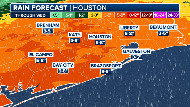
For the rainfall impacts, a wide swath of South Texas, including Brownsville, Corpus Christi and Port Mansfield, are in a Level 2 out of 4 threat for flash flooding on Sunday and Monday. Initial forecasts suggest as much as 4-8 inches of rain along the coastal areas from Brownsville to Houston and even farther inland.

“This is not a (Hurricane) Harvey event, but this is a heavy rain event because the storm is going to be moving more slowly than it is now,” Norcross said. “Now, Texas is not in drought anymore, but it’s not excessively wet either. So they can take some of this rain. But some of this rain over the Hill Country and in metropolitan Houston could be a significant problem.”
Any of the outer rain bands could also produce tropical storm-force gusts and even spin up an isolated tornado, meteorologists with the National Weather Service office in Corpus Christi, Texas said. Winds could increase as early as Sunday morning with peak gusts expected on Monday.