Frigid, bitterly cold temperatures and dangerous wind chills continue across North Texas through Thursday morning.
Temperatures will feel in the single digits through the morning hours.
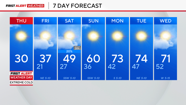
Thursday is another First Alert Weather Day due to wind chills knocking “feels-like” temperatures to dangerous lows. Limit time spent outdoors on Thursday and cover up exposed skin to avoid frostbite.

CBS News Texas
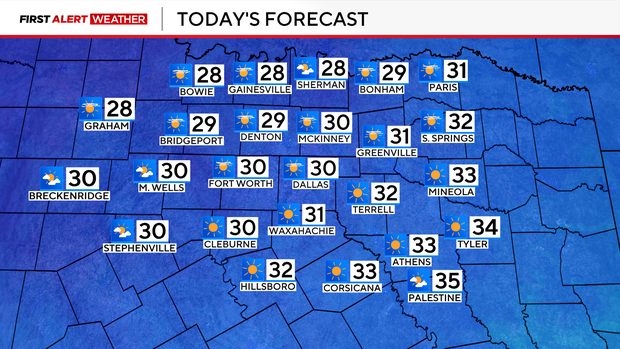
Temperatures Thursday will warm into the high 20s and low 30s.
CBS News Texas
Thursday morning’s low temperature broke a record that was set 86 years ago. The low recorded at Dallas-Fort Worth International Airport was 12 degrees Thursday morning. The last record was set in 1939, at 19 degrees.
The forecast high could also break a record – today’s high is only expected to reach 31 degrees. The current record high is 35 degrees, which was reached on this day in 1904. On Wednesday, the high only reached 28 degrees, setting a new record. The previous record high was 31 degrees on that day in 2006.
Winds won’t gust up to 30 mph like on Wednesday. At 5 a.m., winds across North Texas were blowing between 10-15 mph. An isolated flurry is possible but lake effect snow isn’t likely.
Temperatures in North Texas will remain below freezing until midday Friday. It will be the first time the temperature will be above freezing since Tuesday around 5 p.m.
CBS News Texas
Precipitation chances return on Saturday with an isolated, low chance of rain.

CBS News Texas

Featured Local Savings
