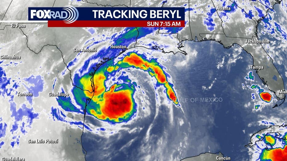
Houston – Tropical Storm Beryl continues to move across the Gulf of Mexico on Sunday on a path for the Texas coast.
As of 1 p.m. Sunday, Beryl was located 165 miles south-southeast of Matagorda and was moving north-northwest at 10 mph. It had maximum sustained winds of 65 mph.
RELATED: Texas prepares for Hurricane Beryl’s landfall
Beryl’s path: Texas and Houston impacts
Although Beryl is still a tropical storm, the latest hurricane hunter data shows a drop in its pressure from 992 millibars to 988. Lower pressure will eventually lead to higher winds, so it still looks like a Category 1 hurricane with a landfall near Matagorda early Monday morning.
SCHOOL CLOSURES: School districts cancel Monday classes as Tropical Storm Beryl approaches
Prepare for a very windy and rainy 12-15 hours or so from overnight tonight through Monday afternoon. Winds of 50 mph and higher, heavy rain, and coastal flooding are possible. Expect the power to go out in many locations.
SUGGESTED: Tropical Storm Beryl tracker: Update on Texas, Houston impacts, path, hurricane watch
Monday is going to be nasty all across the Houston-Galveston area. As of Sunday morning, Beryl has not yet been upgraded to a hurricane, but probably will get stronger Sunday and before the expected landfall very early Monday near Matagorda Bay and possibly even closer to Brazoria County.

Expected Winds from Beryl
Regardless of the landfall location, we expect a large swath of 40-70 mph winds for cities like Freeport, Bay City, Wharton, Rosenberg and possibly Sugar Land, Katy and, by midday, the Great Houston area.
Beryl’s Storm Surge Impact
Galveston Island and bay communities will be threatened by a storm surge of 3-6′ which will cover low-lying roads (some impassible) and may be higher near landfall in Matagorda and Coastal Brazoria Counties.
Beryl’s Rainfall and Flooding
Rainfall could range from 5-10″, so flooding is also a concern on Monday, but fortunately, Beryl will be a fast-mover which will limit the duration of heavy rain.
DOWNLOAD THE FOX 26 HOUSTON APP BY CLICKING HERE
The bottom line is to prepare to not leave your home at all on Monday, so hunker down, be prepared to lose electricity, make sure to have medicines, food that won’t spoil, pet food, all that.
The Town of Quintana has issued a Mandatory Evacuation.
Beryl watches and warnings
STORM SURGE WARNING
A Storm Surge Warning is in effect for North Entrance of the Padre Island National Seashore to Sabine Pass, including Corpus Christi Bay, Matagorda Bay, and Galveston Bay.
HURRICANE WARNING
A Hurricane Warning is in effect for the Texas coast from Baffin Bay northward to San Luis Pass.
HURRICANE WATCH
A Hurricane Watch is in effect for the Texas coast north of San Luis Pass to Galveston Island.
TROPICAL STORM WARNING
A Tropical Storm Warning is in effect for the Texas coast south of Baffin Bay to the mouth of the Rio Grande, the Texas coast north of San Luis Pass to Sabine Pass, and the northeastern coast of mainland Mexico from Barra el Mezquital to the mouth of the Rio Grande River.
STORM SURGE WATCH
A Storm Surge Watch is in effect for north of Baffin Bay, Texas to North Entrance of the Padre Island National Seashore.
Texas prepares for Beryl
Texans are preparing for Tropical Storm Beryl to make an impact on the coast, and Acting Governor Dan Patrick has expanded the state’s disaster declaration to include 81 more counties, bringing the total to 121 counties.
The Texas Division of Emergency Management has raised the readiness level of the State Emergency Operations Center and Texas Emergency Management Council agencies are working around the clock.
Click here to see the list of counties included in the disaster declaration.
Hurricane preparedness list
You should have a disaster preparedness kit ready to go well before a storm is ever on the way. At a minimum, your kit should have the basic supplies like food, water, first aid supplies and flashlights.
Click here to see a list of basic supplies to include in your hurricane preparedness kit.