Friday afternoon saw tornadoes, large hail and damaging winds in parts of North Texas. Multiple rounds of severe storms are possible through the weekend.
DALLAS — Versión en Español: Sol para empezar la semana, pero tormentas para el fin de semana
Quick facts:
- 2 rounds of storm chances this weekend
- Both chances have a severe threat
- Windy Saturday regardless of storms
- Flash flooding possible with heavy rain
Bottom line:
A busy weather weekend in North Texas with gusty winds, thunderstorm chances, and the threat for flash flooding.
Two round of thunderstorms are possible Saturday, Saturday night, and into Sunday morning with the threat for severe weather. However, a cap in place could limit storm chances with round #1.
Keep reading for more details on what to expect through the weekend.

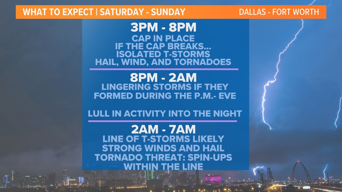

Round #1
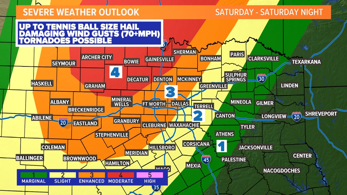
The threat for severe storms with round #1 is what we call “conditional”. This means that storms are not guaranteed to form, but if they do they have a very good chance at being severe with the threat for large hail, damaging winds, and tornadoes.
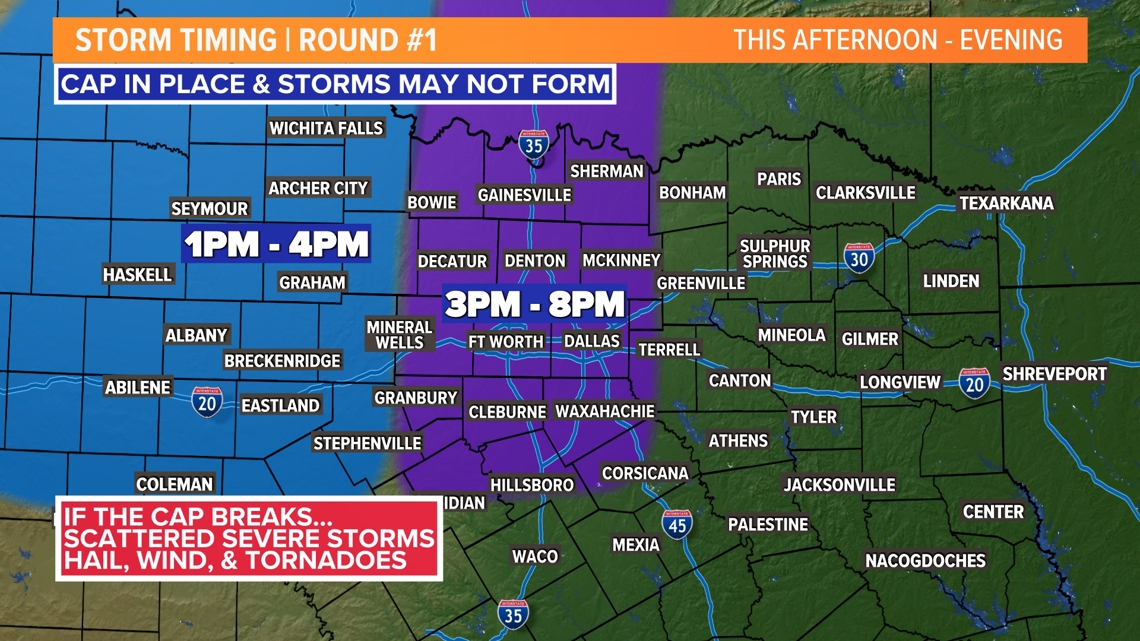
A cap will be in place during the day Saturday, which could limit storm development. However, if the cap breaks, significant severe storms will be possible. While storms may not be widespread, any supercells that form will be capable of up to tennis ball size hail, damaging winds 70+ mph, and tornadoes.
For DFW, the window for the cap to break looks to be around 3 p.m. to 8 p.m., but storms are certainly not guaranteed. Stay weather aware this afternoon into evening in case!

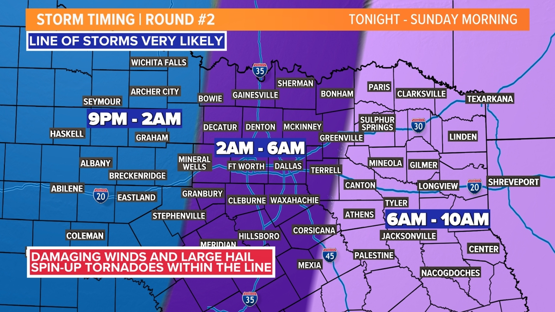
Round #2
This round of storms is very likely for North Texas as a line or broken line of storms will sweep from west to east across the area during the nighttime and overnight hours into Sunday morning.
Storms will form west of North Texas and then move into western areas during the early evening, DFW after midnight thru early Sunday morning, and east of DFW around sunrise or later on Sunday.
Since the storms will be in a line, the main severe threat will be damaging winds 60-70+ mph. However, isolated instances of up to golf ball size hail are possible. The tornado threat will be in the form of spin-ups within the line of storms. These type of tornadoes are usually short-lived and not as strong as ones that come from supercells. However, they can still be very damaging.

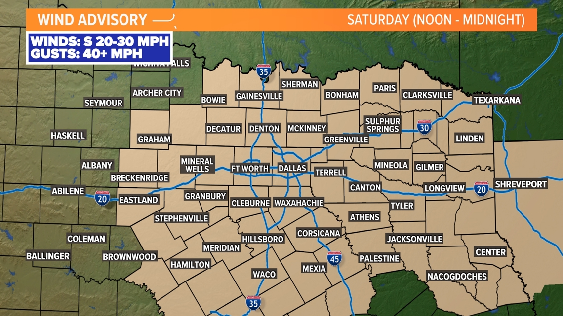
Wind Advisory
Wind will be very gusty on Saturday regardless of any thunderstorms out there. A Wind Advisory is in place from noon through midnight. Gusts from the south of 40+ mph are possible.

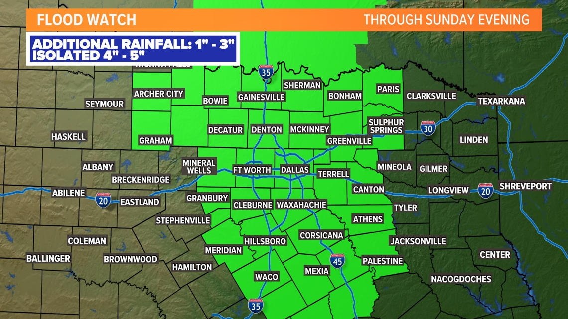
Flood Watch
With heavy rain possible in North Texas at times, a Flood Watch has been issued for most of the area through Sunday evening. Instances of flash flooding and flooding will be possible in areas that see the most rain. Especially those that saw heavy rain from storms on Friday. Across the area around 1-3in are possible with isolated higher amounts.

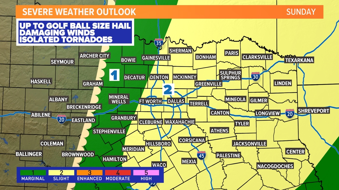
Sunday
The day will start will a line or broken line of storms from DFW to just east of DFW. Some storms could be severe to start the day.
That line will move east into eastern North Texas through the morning. As it does two things could happen:
- The line fizzles out, but redevelops during the afternoon into evening across eastern North Texas into East Texas.
- The line holds together and intensifies during the afternoon into evening across eastern North Texas into East Texas.
Either way, storms are most likely in eastern North Texas during the afternoon and evening with severe storms possible as well. The DFW area looks to be dry during the afternoon and evening.

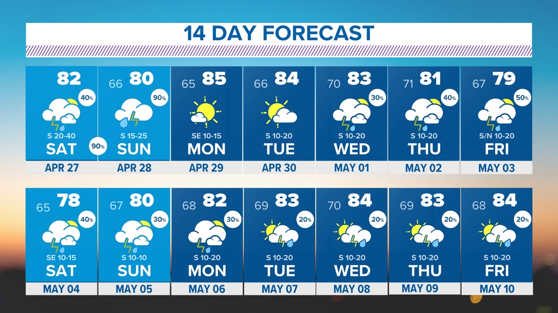
14 Day