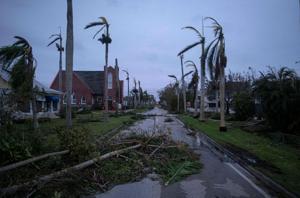
MIAMI — Tropical Storm Ian is causing “catastrophic flooding” over east-central Florida Thursday morning as it treks closer to the Atlantic, forecasters said. Once it’s in the Atlantic, Ian is forecast to near hurricane strength before approaching South Carolina.
And while Ian is much weaker than when it hit Florida’s southwest coast as a devastating Category 4 hurricane Wednesday afternoon, it remains a large storm, with tropical storm-force winds extending up to 415 miles from the center.
The National Hurricane Center in an update at 8 a.m. Thursday said the storm is continuing to batter parts of the state — and will eventually affect Georgia and the Carolinas — with strong winds, heavy rain and storm surge. Nearly all of the storm’s heavy rains are to the north over northeastern Florida, according to the National Hurricane Center.
The hurricane warnings along the east and west coast of Florida, including in Manatee County, were downgraded to tropical storm warnings early Thursday. At 8 a.m., the tropical storm warning from Boca Raton to Jupiter Inlet was discontinued.
“Widespread, life-threatening catastrophic flooding, with major to record river flooding, will continue today across portions of central Florida with considerable flooding in northern Florida, southeastern Georgia and eastern South Carolina expected today through the end of the week,” the hurricane center said.
A flood warning was also extended until at least early Sunday for several rivers along the state’s west coast, including Manatee River in Manatee County, Hillsborough River near Hillsborough River State Park in Hillsborough County, and Myakka River at Myakka River State Park in Sarasota County.
Where is Ian?
Ian is about 40 miles east of Orlando and about 10 miles west of Cape Canaveral, as of the hurricane center’s 8 a.m. advisory. The storm has maximum sustained winds near 65 mph with higher gusts and is moving northeast at 8 mph.
Ian approached Florida on Wednesday with 155 mph winds, just shy of Cat 5 status, before weakening to 150 mph by landfall. The Cat 4 storm made landfall around 3 p.m. Wednesday near Cayo Costa, an island just north of Captiva and off the coast of Fort Myers with few full-time residents and reachable only by boat. A second landfall on the mainland, near Pirate Harbor and north of Punta Gorda, happened around 4:35 p.m.
And it left destruction in its wake along the state’s west coast. The powerful storm submerged streets in Sanibel, Fort Myers Beach and Naples — washing away stop signs, cars, boats and homes. A section of the only causeway to Sanibel collapsed. The storm also damaged the state’s power grid and left over two million Floridians without power.
Ian’s hazards
Forecasters expect northeast Florida, coastal Georgia and parts of South Carolina will see 4 to 8 inches of rain, with some areas possibly seeing up to 12 inches of rain.
“Coastal water levels continue to subside along the west coast of Florida. There is a danger of life-threatening storm surge today through Friday along the coasts of northeast Florida, Georgia, and South Carolina. Residents in these areas should follow any advice given by local officials,” the hurricane center said.
A storm surge warning remains in effect on Florida’s east coast from the Flagler/Volusia Line to the mouth of the South Santee River in South Carolina. This area could see 4 to 6 feet of storm surge. The storm surge warning for Florida’s Gulf coast from the middle of Longboat Key south to Flamingo, including Charlotte Harbor was discontinued Thursday morning.
Storm surge was the biggest threat for Florida’s west coast Wednesday, when the hurricane center predicted 12 to 18 feet of storm surge would be possible along Southwest Florida’s coast from Englewood to Bonita Beach, including Charlotte Harbor. And in South Florida, Key West broke a storm surge record this week with more than two feet of storm surge.
Where is Ian going?
Forecasters expect Ian’s center will move off the east-central coast of Florida later Thursday into the Atlantic, where it could strengthen to maximum sustained winds of 70 mph, just shy of Cat 1 strength while approaching the coast of South Carolina on Friday. To be a Cat 1, it would need to have maximum sustained winds of at least 74 mph.
Once Ian makes landfall in South Carolina, forecasters expect it will weaken quickly and eventually dissipate or be absorbed by another broader area of low pressure while moving farther inland across the Carolinas this weekend.


